Hai perso la password? Nuovo utente? Registra
Clownfish, Philippines. Photo by Stephane Rochon.
Divertiti e contribuisci!
| Trova il miglior sito d'immersione |
|
|
 Namibia
Africa
Posizione: Southern Africa, bordering the South Atlantic Ocean, between Angola and South Africa
Coordinate geografiche: 22° 0' S, 17° 0' E
Linea di costa km: 1,572 km km
Clima: desert; hot, dry; rainfall sparse and erratic
Terreno:
Altitudine:
Pericoli naturali: prolonged periods of drought. very limited natural fresh water resources; desertification; wildlife poaching; land degradation has led to few conservation areas
Valuta: Namibian dollar (NAD); South African rand (ZAR)
Popolazione:
Lingue: English 7% (official), Afrikaans common language of most of the population and about 60% of the white population, German 32%, indigenous languages 1% (includes Oshivambo, Herero, Nama)
Capitale:
Divisioni:
maggiori dettagli
| Jan | Feb | Mar | Apr | May | Jun | Jul | Aug | Sep | Oct | Nov | Dec | |
|---|---|---|---|---|---|---|---|---|---|---|---|---|
| Climate | ||||||||||||
| Air temp. | ||||||||||||
| Water temp. | ||||||||||||
| Equipment | ||||||||||||
| Best season | ||||||||||||
Vuoi inserire alcune informazioni su Namibia? Faccelo sapere
Questa è una mappa interattiva! usa i controlli zoom e pan.
- registro delle immersioni (0)
- viaggi (0)
- Foto (2)
- Video (0)
- Condividi
- Preferito
-
Lista dei tuoi punti d'immersione preferiti e futuri
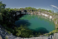
Siti d'immersione
| Siti d'immersione (2) | Qualità | Profondità media | Profondità massima | Esperienza | Tipo d'immersione | ||
|---|---|---|---|---|---|---|---|
| Lake Guinas | - / - | 65 m | 130 m | Kamikaze/Trimix | 


|
||
| Otjikoto Lake | 2 / - | 45 m | 58 m | Kamikaze/Trimix |
|
 Commenti
Sii il primo a commentare questo paese
Errori, Segnalazione
Se vuoi aggiungere altre informazioni o hai riscontrato degli errori per questo Stato, Scrivi una recensione.
Pubblicità
Wannadive.net 24/24
Wannadive.net sul tuo telefono
![]()
RSS Tutti i RSS feeds di Wannadive.net
Newsletter Tutte le notizie per email