Hai perso la password? Nuovo utente? Registra
Whale Shark, Philippines. Photo by Stephane Rochon.
Divertiti e contribuisci!
| Trova il miglior sito d'immersione |
|
|
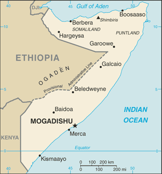
 Somalia
Africa
It is NOT recommanded to organize a dive trip in Somalia now. A civil war started in 2006 and it is dangerous to go there for now.
Posizione: Eastern Africa, bordering the Gulf of Aden and the Indian Ocean, east of Ethiopia
Coordinate geografiche: 10° 0' N, 49° 0' E
Linea di costa km: 3,025 km km
Clima: principally desert; northeast monsoon (December to February), moderate temperatures in north and very hot in south; southwest monsoon (May to October), torrid in the north and hot in the south, irregular rainfall, hot and humid periods (tangambili) between monsoons
Terreno: mostly flat to undulating plateau rising to hills in north
Altitudine: lowest point: Indian Ocean 0 m
highest point: Shimbiris 2,416 m
Pericoli naturali: recurring droughts; frequent dust storms over eastern plains in summer; floods during rainy season
Valuta: Somali shilling (SOS)
Popolazione: 8,863,338 (July 2006 est.)
Lingue: Somali (official), Arabic, Italian, English
Capitale: Mogadishu
Divisioni: 18 regions: Awdal, Bakool, Banaadir, Bari, Bay, Galguduud, Gedo, Hiiraan, Jubbada Dhexe, Jubbada Hoose, Mudug, Nugaal, Sanaag, Shabeellaha Dhexe, Shabeellaha Hoose, Sool, Togdheer, Woqooyi Galbeed
maggiori dettagli
| Jan | Feb | Mar | Apr | May | Jun | Jul | Aug | Sep | Oct | Nov | Dec | |
|---|---|---|---|---|---|---|---|---|---|---|---|---|
| Climate | ||||||||||||
| Air temp. | ||||||||||||
| Water temp. | ||||||||||||
| Equipment | Weet niet | Weet niet | Weet niet | Weet niet | Weet niet | Weet niet | Weet niet | Weet niet | Weet niet | Weet niet | Weet niet | Weet niet |
| Best season | ||||||||||||
Ulteriore Mappa
Vuoi inserire alcune informazioni su Somalia? Faccelo sapere
Questa è una mappa interattiva! usa i controlli zoom e pan.
- registro delle immersioni (0)
- viaggi (0)
- Foto (0)
- Video (0)
- Condividi
- Preferito
-
Lista dei tuoi punti d'immersione preferiti e futuri
La tua zona preferita non è nell'elenco? Aggiungi una zona
Zone
| Zone (1) | Siti d'immersione | Sotto zone |
|---|---|---|
| Bajuni Islands | 1 | 0 |
 Commenti
Sii il primo a commentare questo paese
Errori, Segnalazione
Se vuoi aggiungere altre informazioni o hai riscontrato degli errori per questo Stato, Scrivi una recensione.
Pubblicità
Wannadive.net 24/24
Wannadive.net sul tuo telefono
![]()
RSS Tutti i RSS feeds di Wannadive.net
Newsletter Tutte le notizie per email