Hai perso la password? Nuovo utente? Registra
Clownfish, Philippines. Photo by Stephane Rochon.
Divertiti e contribuisci!
| Trova il miglior sito d'immersione |
|
|
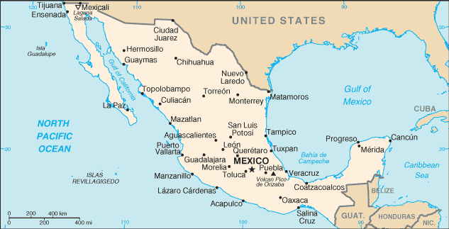
 Mexico
America Centrale
Posizione: Middle America, bordering the Caribbean Sea and the Gulf of Mexico, between Belize and the US and bordering the North Pacific Ocean, between Guatemala and the US
Coordinate geografiche: 23° 0' N, 102° 0' W
Linea di costa km: 9,330 km km
Clima: varies from tropical to desert
Terreno: high, rugged mountains; low coastal plains; high plateaus; desert
Altitudine: lowest point: Laguna Salada -10 m
highest point: Volcan Pico de Orizaba 5,700 m
Pericoli naturali: tsunamis along the Pacific coast, volcanoes and destructive earthquakes in the center and south, and hurricanes on the Pacific, Gulf of Mexico, and Caribbean coasts
Valuta: Mexican peso (MXN)
Popolazione: 106,202,903 (July 2005 est.)
Lingue: Spanish, various Mayan, Nahuatl, and other regional indigenous languages
Capitale: Mexico
Divisioni: 31 states and 1 federal district* ; Aguascalientes, Baja California, Baja California Sur, Campeche, Chiapas, Chihuahua, Coahuila de Zaragoza, Colima, Distrito Federal*, Durango, Guanajuato, Guerrero, Hidalgo, Jalisco, Mexico, Michoacan de Ocampo, Morelos, Nayarit, Nuevo Leon, Oaxaca, Puebla, Queretaro de Arteaga, Quintana Roo, San Luis Potosi, Sinaloa, Sonora, Tabasco, Tamaulipas, Tlaxcala, Veracruz-Llave, Yucatan, Zacatecas
maggiori dettagli
| Jan | Feb | Mar | Apr | May | Jun | Jul | Aug | Sep | Oct | Nov | Dec | |
|---|---|---|---|---|---|---|---|---|---|---|---|---|
| Climate | ||||||||||||
| Air temp. | ||||||||||||
| Water temp. | ||||||||||||
| Equipment | ||||||||||||
| Best season | ||||||||||||
Ulteriore Mappa
Vuoi inserire alcune informazioni su Mexico? Faccelo sapere
Questa è una mappa interattiva! usa i controlli zoom e pan.
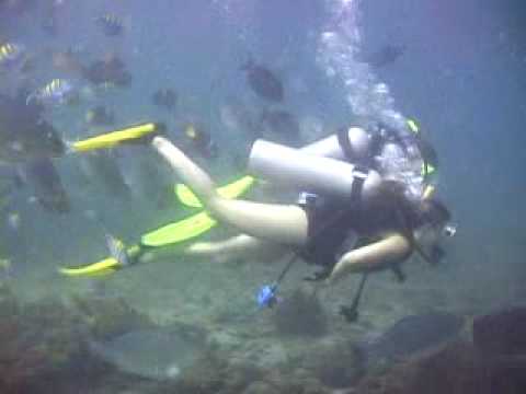
- registro delle immersioni (472)
- viaggi (33)
- Foto (507)
- Video (14)
- Condividi
- Preferito
-
Lista dei tuoi punti d'immersione preferiti e futuri
La tua zona preferita non è nell'elenco? Aggiungi una zona
Zone
| Zone (9) | Siti d'immersione | Sotto zone |
|---|---|---|
| Baja California | 48 | 5 |
| Capital Region | 2 | 1 |
| Central Highlands | 2 | 0 |
| Central Pacific | 24 | 3 |
| Islas Revillagigedos | 6 | 0 |
| Northeast - Monterrey | 1 | 0 |
| Northwest - Sinaloa & Sonora | 35 | 3 |
| Southern Gulf of Mexico | 10 | 1 |
| Yucatán Peninsula | 123 | 9 |


 Dive logs
|
Viaggi subacquei
|
Commenti
Di schris , 11-04-2018
Use wannadive zone download link - There are only two dive site for now in this area; you can download them from https://www.wannadive.net/spot/Central_America/Mexico/Baja_California/La_Paz___Isla_Partida/ See the download link and click on the available output format.
Di dfb72es , 10-04-2018
COORDENADAS GPS - HOLA A TODOS, ESTOY EN LA BÚSQUEDA DE COORDENADAS GPS DE TODO LO QUE ESTE SUMERGIDO EN LA ZONA DE LA PAZ BCS MX.
GRACIAS
Errori, Segnalazione
Se vuoi aggiungere altre informazioni o hai riscontrato degli errori per questo Stato, Scrivi una recensione.
Pubblicità
Wannadive.net 24/24
Wannadive.net sul tuo telefono
![]()
RSS Tutti i RSS feeds di Wannadive.net
Newsletter Tutte le notizie per email