Hai perso la password? Nuovo utente? Registra
Clownfish, Philippines. Photo by Stephane Rochon.
Divertiti e contribuisci!
| Trova il miglior sito d'immersione |
|
|
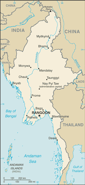
 Burma
Burma
Asia
Burma, officially the Union of Myanmar, is the largest country by geographical area in mainland Southeast Asia or Indochina. The country is bordered by China on the northeast, Laos on the east, Thailand on the southeast, Bangladesh on the west, India on the northwest and the Bay of Bengal to the southwest with the Andaman Sea defining its southern periphery. One-third of Burma's total perimeter, 1,930 kilometres (1,199 mi), forms an uninterrupted coastline.
Posizione: Southeastern Asia, bordering the Andaman Sea and the Bay of Bengal, between Bangladesh and Thailand
Coordinate geografiche: 22° 0' N, 98° 0' E
Linea di costa km: 1,930 km km
Clima: tropical monsoon; cloudy, rainy, hot, humid summers (southwest monsoon, June to September); less cloudy, scant rainfall, mild temperatures, lower humidity during winter (northeast monsoon, December to April)
Terreno: central lowlands ringed by steep, rugged highlands
Altitudine: lowest point: Andaman Sea 0 m
highest point: Hkakabo Razi 5,881 m
Pericoli naturali: petroleum, timber, tin, antimony, zinc, copper, tungsten, lead, coal, marble, limestone, precious stones, natural gas, hydropower
Valuta: kyats (MMK)
Popolazione: 48,137,741 (July 2009 est.)
Lingue: Burmese, minority ethnic groups have their own languages
Capitale: Rangoon (Yangon)
Divisioni: 7 divisions and 7 states:
- divisions: Ayeyarwady, Bago, Magway, Mandalay, Sagaing, Tanintharyi, Yangon
- states: Chin, Kachin, Kayah, Kayin, Mon, Rakhine, Shan
maggiori dettagli
| Jan | Feb | Mar | Apr | May | Jun | Jul | Aug | Sep | Oct | Nov | Dec | |
|---|---|---|---|---|---|---|---|---|---|---|---|---|
| Climate | ||||||||||||
| Air temp. | ||||||||||||
| Water temp. | ||||||||||||
| Equipment | No ho sé | No ho sé | No ho sé | No ho sé | No ho sé | No ho sé | No ho sé | No ho sé | No ho sé | No ho sé | No ho sé | No ho sé |
| Best season | ||||||||||||
Ulteriore Mappa
Vuoi inserire alcune informazioni su Burma? Faccelo sapere
Questa è una mappa interattiva! usa i controlli zoom e pan.
- registro delle immersioni (0)
- viaggi (0)
- Foto (7)
- Video (4)
- Condividi
- Preferito
-
Lista dei tuoi punti d'immersione preferiti e futuri
La tua zona preferita non è nell'elenco? Aggiungi una zona
Zone
| Zone (1) | Siti d'immersione | Sotto zone |
|---|---|---|
| Mergui Archipelago | 6 | 0 |
Siti d'immersione
| Siti d'immersione (1) | Qualità | Profondità media | Profondità massima | Esperienza | Tipo d'immersione | ||
|---|---|---|---|---|---|---|---|
| Silvertip Bank | - / - | 59.1 ft | 98.4 ft | CMAS * / OW | 
|
 Video
Video
 04:54
04:54
|
 04:00
04:00
|
 04:13
04:13
|
 03:32
03:32
|
Commenti
Errori, Segnalazione
Se vuoi aggiungere altre informazioni o hai riscontrato degli errori per questo Stato, Scrivi una recensione.
Pubblicità
Wannadive.net 24/24
Wannadive.net sul tuo telefono
![]()
RSS Tutti i RSS feeds di Wannadive.net
Newsletter Tutte le notizie per email