Hai perso la password? Nuovo utente? Registra
Big eye, Philippines. Photo by Stephane Rochon.
Divertiti e contribuisci!
| Trova il miglior sito d'immersione |
|
|
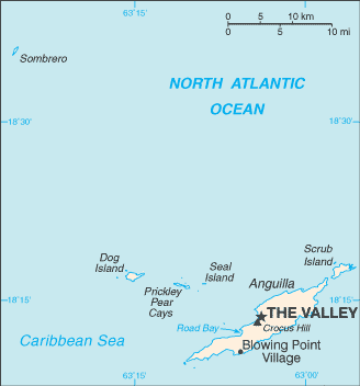
 Anguilla
America Centrale
Posizione: Caribbean, islands between the Caribbean Sea and North Atlantic Ocean, east of Puerto Rico
Coordinate geografiche: 18° 15' N, 63° 10' W
Linea di costa km: 61 km km
Clima: tropical; moderated by northeast trade winds
Terreno: flat and low-lying island of coral and limestone
Altitudine: lowest point: Caribbean Sea 0 m
highest point: Crocus Hill 65 m
Pericoli naturali: frequent hurricanes and other tropical storms (July to October)
Valuta: East Caribbean dollar (XCD)
Popolazione: 13,677 (July 2007 est.)
Lingue: English (official)
Capitale: The Valley
Divisioni: none (overseas territory of the UK)
maggiori dettagli
| Jan | Feb | Mar | Apr | May | Jun | Jul | Aug | Sep | Oct | Nov | Dec | |
|---|---|---|---|---|---|---|---|---|---|---|---|---|
| Climate | ||||||||||||
| Air temp. | ||||||||||||
| Water temp. | ||||||||||||
| Equipment | Don't know | Don't know | Don't know | Don't know | Don't know | Don't know | Don't know | Don't know | Don't know | Don't know | Don't know | Don't know |
| Best season | ||||||||||||
Ulteriore Mappa
Vuoi inserire alcune informazioni su Anguilla? Faccelo sapere
Questa è una mappa interattiva! usa i controlli zoom e pan.
- registro delle immersioni (76)
- viaggi (10)
- Foto (1)
- Video (0)
- Condividi
- Preferito
-
Lista dei tuoi punti d'immersione preferiti e futuri
Siti d'immersione
| Siti d'immersione (21) | Qualità | Profondità media | Profondità massima | Esperienza | Tipo d'immersione | ||
|---|---|---|---|---|---|---|---|
| Angel Reef | - / - | 15 m | 19.8 m | Tutti i subacquei | 
|
||
| Anguillita | - / - | 10.7 m | 18.3 m | CMAS * / OW | 
|
||
| Beacon | - / - | 15 m | 21.3 m | Tutti i subacquei |
|
||
| Blowing Rock | - / - | 9.1 m | 12.2 m | Tutti i subacquei | 

|
||
| Captain Turtle | - / - | 15 m | 19.8 m | Tutti i subacquei |
|
||
| Crystal Reef | - / - | 16.5 m | 25 m | CMAS * / OW |
|
||
| Dog Island | - / - | 20 m | 30.5 m | CMAS ** / AOW | 
|
||
| Frenchman's Reef | - / - | 20 m | 30.5 m | CMAS * / OW |
|
||
| Lobster Reef | - / - | 18 m | 30.5 m | Tutti i subacquei |
|
||
| MV Catheley H Wreck | - / - | 10.7 m | 18.3 m | Tutti i subacquei |
|
||
| MV Commerce | - / - | 20 m | 25 m | CMAS * / OW | 
|
||
| MV Ida Maria Wreck | - / - | 12.2 m | 18.3 m | CMAS * / OW |
|
||
| MV Oosterdiep | - / - | 24.4 m | 25 m | Tutti i subacquei |
|
||
| MV Sarah | - / - | 20 m | 25.9 m | CMAS * / OW |
|
||
| No Name Reef | 1 / - | 12.2 m | 16.8 m | Tutti i subacquei |
|
||
| Prickly Pear | - / - | 5 m | 17 m | Tutti i subacquei |
|
||
| Sea Fan | - / - | 10 m | 12.2 m | Tutti i subacquei |
|
||
| Shoal Bay Reef | - / - | 18 m | 25.9 m | Tutti i subacquei |
|
||
| Teigland | - / - | 15 m | 21 m | Tutti i subacquei |
|
||
| The Garden | - / - | 25 m | 34.1 m | CMAS * / OW |
|
||
| West Cay | - / - | 15 m | 32 m | CMAS * / OW |
|
 Dive logs
|
Viaggi subacquei
|
Commenti
Errori, Segnalazione
Se vuoi aggiungere altre informazioni o hai riscontrato degli errori per questo Stato, Scrivi una recensione.
Pubblicità
Wannadive.net 24/24
Wannadive.net sul tuo telefono
![]()
RSS Tutti i RSS feeds di Wannadive.net
Newsletter Tutte le notizie per email