Hai perso la password? Nuovo utente? Registra
Clownfish, Philippines. Photo by Stephane Rochon.
Divertiti e contribuisci!
| Trova il miglior sito d'immersione |
|
|
 Faroe Islands
Europa
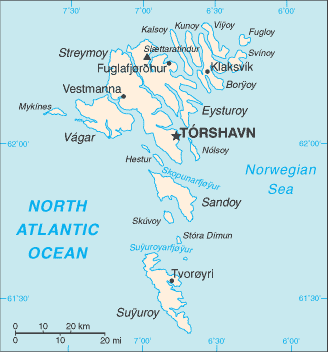
Posizione: Faroe Islands (or Faeroe Islands) Northern Europe, island group between the Norwegian Sea and the North Atlantic Ocean, about half way between Iceland and Norway
Coordinate geografiche: 62° 0' N, 7° 0' W
Linea di costa km: 1,117 km km
Clima: mild winters, cool summers; usually overcast; foggy, windy
Terreno: rugged, rocky, some low peaks; cliffs along most of coast
Altitudine: lowest point: Atlantic Ocean 0 m
highest point: Slaettaratindur 882 m
Pericoli naturali: NA
Valuta: Danish krone (DKK) ?
Popolazione: 48,668 (July 2008 est.)
Lingue: Faroese (derived from Old Norse), Danish
Capitale: Torshavn
Divisioni: part of the Kingdom of Denmark; self-governing overseas administrative division of Denmark
maggiori dettagli
| Jan | Feb | Mar | Apr | May | Jun | Jul | Aug | Sep | Oct | Nov | Dec | |
|---|---|---|---|---|---|---|---|---|---|---|---|---|
| Climate | ||||||||||||
| Air temp. | ||||||||||||
| Water temp. | ||||||||||||
| Equipment | Weet niet | Weet niet | Weet niet | Weet niet | Weet niet | Weet niet | Weet niet | Weet niet | Weet niet | Weet niet | Weet niet | Weet niet |
| Best season | ||||||||||||
Ulteriore Mappa
Vuoi inserire alcune informazioni su Faroe Islands? Faccelo sapere
Questa è una mappa interattiva! usa i controlli zoom e pan.
- registro delle immersioni (1)
- viaggi (0)
- Foto (0)
- Video (0)
- Condividi
- Preferito
-
Lista dei tuoi punti d'immersione preferiti e futuri
Siti d'immersione
| Siti d'immersione (2) | Qualità | Profondità media | Profondità massima | Esperienza | Tipo d'immersione | ||
|---|---|---|---|---|---|---|---|
| Nolsoe | - / - | 18 m | 25 m | CMAS ** / AOW | 


|
||
| Olavur Gregersen Wreck | - / - | 12.6 m | 28.6 m | CMAS ** / AOW | 

|
 Dive logs
Commenti
Errori, Segnalazione
Se vuoi aggiungere altre informazioni o hai riscontrato degli errori per questo Stato, Scrivi una recensione.
Pubblicità
Wannadive.net 24/24
Wannadive.net sul tuo telefono
![]()
RSS Tutti i RSS feeds di Wannadive.net
Newsletter Tutte le notizie per email