Questa è una mappa interattiva! usa i controlli zoom e pan.
Accesso
|
English (Traduci questo testo in Italiano): SW of Grand Bahama island: just W of Silver Point and E of Xanadu Beach, about 1.5 miles off the coast. Two permanent buoys mark the ship’s position (one at the bow and one at the stern).
English (Traduci questo testo in Italiano): SW of Grand Bahama island: just W of Silver Point and E of Xanadu Beach, about 1.5 miles off the coast. Two permanent buoys mark the ship’s position (one at the bow and one at the stern).
SW of Grand Bahama island: just W of Silver Point and E of Xanadu Beach, about 1.5 miles off the coast. Two permanent buoys mark the ship’s position (one at the bow and one at the stern).
English (Traduci questo testo in Italiano): SW of Grand Bahama island: just W of Silver Point and E of Xanadu Beach, about 1.5 miles off the coast. Two permanent buoys mark the ship’s position (one at the bow and one at the stern).
English (Traduci questo testo in Italiano): SW of Grand Bahama island: just W of Silver Point and E of Xanadu Beach, about 1.5 miles off the coast. Two permanent buoys mark the ship’s position (one at the bow and one at the stern).
English (Traduci questo testo in Italiano): SW of Grand Bahama island: just W of Silver Point and E of Xanadu Beach, about 1.5 miles off the coast. Two permanent buoys mark the ship’s position (one at the bow and one at the stern).
English (Traduci questo testo in Italiano): SW of Grand Bahama island: just W of Silver Point and E of Xanadu Beach, about 1.5 miles off the coast. Two permanent buoys mark the ship’s position (one at the bow and one at the stern).
English (Traduci questo testo in Italiano): SW of Grand Bahama island: just W of Silver Point and E of Xanadu Beach, about 1.5 miles off the coast. Two permanent buoys mark the ship’s position (one at the bow and one at the stern).
English (Traduci questo testo in Italiano): SW of Grand Bahama island: just W of Silver Point and E of Xanadu Beach, about 1.5 miles off the coast. Two permanent buoys mark the ship’s position (one at the bow and one at the stern).
Come? In barca
Distanza Buona navigazione (< 30min)
Facile da trovare? Difficile da trovare
|
|
Caratteristiche del sito d'immersione
Nome alternativo M/S Logna
Profondità media 25 m / 82 ft
profondità massima 31 m / 101.7 ft
Corrente Poca ( < 1 nodo)
Visibilità Buona ( 10 - 30 m)
Qualità
Qualità del sito d'immersione Buono
Esperienza CMAS ** / AOW
Interesse biologico Spettacolare
Più dettagli
Frequentazione durante la settimana
Frequentazione durante il Week-end
Tipo di immersione
- Relitto
Attività per il sito
- Fotografia
Pericoli
Altre informazioni
English (Traduci questo testo in Italiano): This 230 feet long vessel was built in Norway in 1954. It was intentionally sunk october 16, 1982. She now lays on her port side on a flat sandy floor, not far from few isolated coral banks.
English (Traduci questo testo in Italiano): This 230 feet long vessel was built in Norway in 1954. It was intentionally sunk october 16, 1982. She now lays on her port side on a flat sandy floor, not far from few isolated coral banks.
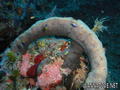
This 230 feet long vessel was built in Norway in 1954. It was intentionally sunk october 16, 1982. She now lays on her port side on a flat sandy floor, not far from few isolated coral banks.
English (Traduci questo testo in Italiano): This 230 feet long vessel was built in Norway in 1954. It was intentionally sunk october 16, 1982. She now lays on her port side on a flat sandy floor, not far from few isolated coral banks.
English (Traduci questo testo in Italiano): This 230 feet long vessel was built in Norway in 1954. It was intentionally sunk october 16, 1982. She now lays on her port side on a flat sandy floor, not far from few isolated coral banks.
English (Traduci questo testo in Italiano): This 230 feet long vessel was built in Norway in 1954. It was intentionally sunk october 16, 1982. She now lays on her port side on a flat sandy floor, not far from few isolated coral banks.
English (Traduci questo testo in Italiano): This 230 feet long vessel was built in Norway in 1954. It was intentionally sunk october 16, 1982. She now lays on her port side on a flat sandy floor, not far from few isolated coral banks.
English (Traduci questo testo in Italiano): This 230 feet long vessel was built in Norway in 1954. It was intentionally sunk october 16, 1982. She now lays on her port side on a flat sandy floor, not far from few isolated coral banks.
English (Traduci questo testo in Italiano): This 230 feet long vessel was built in Norway in 1954. It was intentionally sunk october 16, 1982. She now lays on her port side on a flat sandy floor, not far from few isolated coral banks.
 Commenti
Per favore login per usare questo strumento.
Non hai ancora un account? Registrati prima; è gratis!
Mostra tutto (2)...
Errori, Segnalazione
Puoi modificare questa pagina per correggere errori o aggiungere altre informazioni. Se hai problemi riguardo questa pagina, Scrivi una recensione.
Wannadive.net 24/24
Wannadive.net sul tuo telefono

Newsletter Tutte le notizie per email
 Theo's Wreck

Di Theo Galanopoulos , 14-05-2010
Theo (From Theo's Wreck) - I Like the plaque... Thanks