Questa è una mappa interattiva! usa i controlli zoom e pan.
Accesso
|
English (Traduci questo testo in Italiano): The MV Keith Tibbetts rests on the northern shores of Cayman Brac.
It is generally accessible only by boat, but can also be accessed (via a long swim) from the 'Bucaneer' shore access point: take a compass bearing off of one of the mooring balls and expect a moderate longitudinal current (typically east to west, which would be right-to-left on the swim out).
By boat, the site is moored (generally two moorings directly on the wreck, one forward and one to stern). The shore landmark to find the moorings is a cut in the ironshore located at the site of the old Bucaneer hotel property. This is easy to spot from a distance offshore because of a 25ft tall rockpile next to the cut. If the rockpile is ever removed, there's also two yellow marker signs that signify the border of the Marine Park located on the shore at the inlet.
If you miss the Bucaneer landmark, slightly further to the west is a rock jetty which is the Scott Development dock where they load gravel for export to Grand Cayman (and only occasionally killing the surrounding reef with accidental gravel spills). This jetty might be eventually made into a Cruise Ship dock for the Brac.
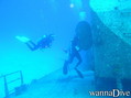
The MV Keith Tibbetts rests on the northern shores of Cayman Brac.
It is generally accessible only by boat, but can also be accessed (via a long swim) from the 'Bucaneer' shore access point: take a compass bearing off of one of the mooring balls and expect a moderate longitudinal current (typically east to west, which would be right-to-left on the swim out).
By boat, the site is moored (generally two moorings directly on the wreck, one forward and one to stern). The shore landmark to find the moorings is a cut in the ironshore located at the site of the old Bucaneer hotel property. This is easy to spot from a distance offshore because of a 25ft tall rockpile next to the cut. If the rockpile is ever removed, there's also two yellow marker signs that signify the border of the Marine Park located on the shore at the inlet.
If you miss the Bucaneer landmark, slightly further to the west is a rock jetty which is the Scott Development dock where they load gravel for export to Grand Cayman (and only occasionally killing the surrounding reef with accidental gravel spills). This jetty might be eventually made into a Cruise Ship dock for the Brac.
English (Traduci questo testo in Italiano): The MV Keith Tibbetts rests on the northern shores of Cayman Brac.
It is generally accessible only by boat, but can also be accessed (via a long swim) from the 'Bucaneer' shore access point: take a compass bearing off of one of the mooring balls and expect a moderate longitudinal current (typically east to west, which would be right-to-left on the swim out).
By boat, the site is moored (generally two moorings directly on the wreck, one forward and one to stern). The shore landmark to find the moorings is a cut in the ironshore located at the site of the old Bucaneer hotel property. This is easy to spot from a distance offshore because of a 25ft tall rockpile next to the cut. If the rockpile is ever removed, there's also two yellow marker signs that signify the border of the Marine Park located on the shore at the inlet.
If you miss the Bucaneer landmark, slightly further to the west is a rock jetty which is the Scott Development dock where they load gravel for export to Grand Cayman (and only occasionally killing the surrounding reef with accidental gravel spills). This jetty might be eventually made into a Cruise Ship dock for the Brac.
Come? In barca e da riva
Distanza Buona navigazione (< 30min)
Facile da trovare? Facile da trovare
|
|
Caratteristiche del sito d'immersione
Nome alternativo 356 Russian Destroyer
Profondità media 20 m / 65.6 ft
profondità massima 35 m / 114.8 ft
Corrente Poca ( < 1 nodo)
Visibilità Eccellente ( > 30 m)
Qualità
Qualità del sito d'immersione Buono
Esperienza Tutti i subacquei
Interesse biologico Interessante
Più dettagli
Frequentazione durante la settimana
Frequentazione durante il Week-end
Tipo di immersione
- Relitto
- Parete
- Reef
Attività per il sito
- Biologia marina
- Allenamento
- Orientamento
- Fotografia
Pericoli
- Traffico nautico
Altre informazioni
English (Traduci questo testo in Italiano): The MV Captain Keith Tibbetts was sunk in 1996 as an artificial reef. Since then, coral has grown nicely on the wreck. The wreck has since had its back broken by a Winter Nor'Wester storm which has resulted in a nice debris field amidships. It remains an interesting wreck with plenty to see on the outside, plus there's a couple of well-known and reasonably safe penetration opportunities. Fish life is present and is typical for the region, with local DMs often aware of where a resident Scorpionfish or two are residing.
The area off the bow of the ship leads out into a deeper sandflat area, and then coral formations at the wall dropoff. This area is not frequented by most divers who come to this mooring, partly because it isn't the wreck proper, but also because the dropoff starts deep, in approximately 110fsw. As with any bluewater dropoff, pelagics can occasionally be spotted in this area.
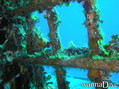
The MV Captain Keith Tibbetts was sunk in 1996 as an artificial reef. Since then, coral has grown nicely on the wreck. The wreck has since had its back broken by a Winter Nor'Wester storm which has resulted in a nice debris field amidships. It remains an interesting wreck with plenty to see on the outside, plus there's a couple of well-known and reasonably safe penetration opportunities. Fish life is present and is typical for the region, with local DMs often aware of where a resident Scorpionfish or two are residing.
The area off the bow of the ship leads out into a deeper sandflat area, and then coral formations at the wall dropoff. This area is not frequented by most divers who come to this mooring, partly because it isn't the wreck proper, but also because the dropoff starts deep, in approximately 110fsw. As with any bluewater dropoff, pelagics can occasionally be spotted in this area.
English (Traduci questo testo in Italiano): The MV Captain Keith Tibbetts was sunk in 1996 as an artificial reef. Since then, coral has grown nicely on the wreck. The wreck has since had its back broken by a Winter Nor'Wester storm which has resulted in a nice debris field amidships. It remains an interesting wreck with plenty to see on the outside, plus there's a couple of well-known and reasonably safe penetration opportunities. Fish life is present and is typical for the region, with local DMs often aware of where a resident Scorpionfish or two are residing.
The area off the bow of the ship leads out into a deeper sandflat area, and then coral formations at the wall dropoff. This area is not frequented by most divers who come to this mooring, partly because it isn't the wreck proper, but also because the dropoff starts deep, in approximately 110fsw. As with any bluewater dropoff, pelagics can occasionally be spotted in this area.
 Commenti
Per favore login per usare questo strumento.
Non hai ancora un account? Registrati prima; è gratis!
Mostra tutto (0)...
Sii il primo a commentare questo paese
Errori, Segnalazione
Puoi modificare questa pagina per correggere errori o aggiungere altre informazioni. Se hai problemi riguardo questa pagina, Scrivi una recensione.
 MV Captain Keith Tibbetts