Questa è una mappa interattiva! usa i controlli zoom e pan.
Accesso
|
Es pot aparcar pràcticament al costat, molt a prop de la residència d'estiu del president d'Islàndia, dins el Parc Nacional de Thingvellir.
English (Traduci questo testo in Italiano): Thingvellir National Park. Short walking distant to a ladder.
Thingvellir National Park. Short walking distant to a ladder.
English (Traduci questo testo in Italiano): Thingvellir National Park. Short walking distant to a ladder.
English (Traduci questo testo in Italiano): Thingvellir National Park. Short walking distant to a ladder.
English (Traduci questo testo in Italiano): Thingvellir National Park. Short walking distant to a ladder.
English (Traduci questo testo in Italiano): Thingvellir National Park. Short walking distant to a ladder.
English (Traduci questo testo in Italiano): Thingvellir National Park. Short walking distant to a ladder.
English (Traduci questo testo in Italiano): Thingvellir National Park. Short walking distant to a ladder.
Come? Da riva
Distanza Breve camminata da riva (< 5min)
Facile da trovare? Facile da trovare
|
|
Caratteristiche del sito d'immersione
Profondità media 26 m / 85.3 ft
profondità massima 59 m / 193.6 ft
Corrente Poca ( < 1 nodo)
Visibilità Eccellente ( > 30 m)
Qualità
Qualità del sito d'immersione Grande
Esperienza CMAS ** / AOW
Interesse biologico Interessante
Più dettagli
Frequentazione durante la settimana
Frequentazione durante il Week-end
Tipo di immersione
- Acqua dolce
- Grotta
Attività per il sito
- Notturna
- Allenamento
- Snorkeling / Apnea
- Fotografia
Pericoli
Altre informazioni
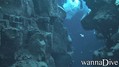
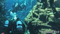
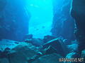
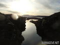
Es tracta d'una esquerda a la roca, situada al bell mig de la dorsal atlàntica, en el punt on les plaques europea i nord-americana se separen a raó de dos centímetres anuals. L'aigua és considerada la més transparent del món, amb una visibilitat superior a 150 metres, i prové d'una gelera relativament propera, encara que triga més de trenta anys a arribar-hi. És molt freda, entre 2 i 4ºC, però no es gela mai. Cal fer immersió amb vestit sec.
English (Traduci questo testo in Italiano): Imagine a large fissure filled up with icy, but crystal clear water, having a visibility of 50 meters and more, no suspended plankton, water just like the air around you. This is Silfra!
The sensational experience while diving in Silfra is just outstanding. The first part of the fissure is characterized by a deep cave leading under the road. The following part is divided by several deep ponds that are connected by tunnels in between the lava rocks. Even more impressive are the deep canyons that go down to 59 meters. From the bottom, the bubbles are searching their way up to the surface, disappearing in the intense blue filtered sunlight breaking the surface.
The landscape is marked geographically by a huge depression between two rifts running north-east. As the two main continental tectonic plates are drifting here apart (2 cm per year), the rift valley is constantly sinking. The result of this geological phenomenon is the lake Þingvallavatn - the largest natural lake in Iceland.
Imagine a large fissure filled up with icy, but crystal clear water, having a visibility of 50 meters and more, no suspended plankton, water just like the air around you. This is Silfra!
The sensational experience while diving in Silfra is just outstanding. The first part of the fissure is characterized by a deep cave leading under the road. The following part is divided by several deep ponds that are connected by tunnels in between the lava rocks. Even more impressive are the deep canyons that go down to 59 meters. From the bottom, the bubbles are searching their way up to the surface, disappearing in the intense blue filtered sunlight breaking the surface.
The landscape is marked geographically by a huge depression between two rifts running north-east. As the two main continental tectonic plates are drifting here apart (2 cm per year), the rift valley is constantly sinking. The result of this geological phenomenon is the lake Þingvallavatn - the largest natural lake in Iceland.
English (Traduci questo testo in Italiano): Imagine a large fissure filled up with icy, but crystal clear water, having a visibility of 50 meters and more, no suspended plankton, water just like the air around you. This is Silfra!
The sensational experience while diving in Silfra is just outstanding. The first part of the fissure is characterized by a deep cave leading under the road. The following part is divided by several deep ponds that are connected by tunnels in between the lava rocks. Even more impressive are the deep canyons that go down to 59 meters. From the bottom, the bubbles are searching their way up to the surface, disappearing in the intense blue filtered sunlight breaking the surface.
The landscape is marked geographically by a huge depression between two rifts running north-east. As the two main continental tectonic plates are drifting here apart (2 cm per year), the rift valley is constantly sinking. The result of this geological phenomenon is the lake Þingvallavatn - the largest natural lake in Iceland.
 Dive logs
Mostra tutto (5)...

|
Per
Super dive - The best dive ever! Visit it if you ever get to iceland... You can by a trip to the site on dive.is
Més... |
|
Commenti
Per favore login per usare questo strumento.
Non hai ancora un account? Registrati prima; è gratis!
Mostra tutto (2)...
Errori, Segnalazione
Puoi modificare questa pagina per correggere errori o aggiungere altre informazioni. Se hai problemi riguardo questa pagina, Scrivi una recensione.
 Silfra