Hai perso la password? Nuovo utente? Registra
Clownfish, Philippines. Photo by Stephane Rochon.
Divertiti e contribuisci!
| Trova il miglior sito d'immersione |
|
|
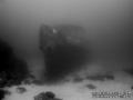
 Imperial Eagle MV
Malta, Malta island
Questa è una mappa interattiva! usa i controlli zoom e pan.
|
Datum: WGS84 [ Aiuto ] |
Latitudine: 35° 57.096' N |
Giudizio dell'utente (1)
- Preferito
-
Lista dei tuoi punti d'immersione preferiti e futuri
Accesso
|
Come? In barca Distanza Buona navigazione (< 30min) Facile da trovare? Facile da trovare |
Caratteristiche del sito d'immersione
Nome alternativo Imperial Eagle ferry
Profondità media 35 m / 114.8 ft
profondità massima 46 m / 150.9 ft
Corrente Poca ( < 1 nodo)
Visibilità Buona ( 10 - 30 m)
Qualità
Qualità del sito d'immersione Grande
Esperienza CMAS ** / AOW
Interesse biologico Interessante
Più dettagli
Frequentazione durante la settimana
Frequentazione durante il Week-end
Tipo di immersione
- Relitto
Attività per il sito
- Allenamento
- Fotografia
Pericoli
- Profondità
Altre informazioni
English (Traduci questo testo in Italiano): The Imperial Eagle was one of the ferryboats connecting Malta and Gozo.
The hull, in navigation trim, lays on a sandy bottom at a depth of -42m, 300m North-East of Qwara Point.
Autore: Vladimir Dunaev Hanno contribuito (1) Si sono immersi qua! (6)
 Foto
Foto

Imperial Eagle MV |

Imperial Eagle MV |

Imperial Eagle MV |
Imperial Eagle MV |
Commenti
Sii il primo a commentare questo paese
Errori, Segnalazione
Puoi modificare questa pagina per correggere errori o aggiungere altre informazioni. Se hai problemi riguardo questa pagina, Scrivi una recensione.
Pubblicità
Wannadive.net 24/24
Wannadive.net sul tuo telefono
![]()
RSS Tutti i RSS feeds di Wannadive.net
Newsletter Tutte le notizie per email