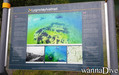
Questa è una mappa interattiva! usa i controlli zoom e pan.
Accesso
|
English (Traduci questo testo in Italiano): Access from route 655 from øye in too the mountain
English (Traduci questo testo in Italiano): Access from route 655 from øye in too the mountain
Access from route 655 from øye in too the mountain
English (Traduci questo testo in Italiano): Access from route 655 from øye in too the mountain
English (Traduci questo testo in Italiano): Access from route 655 from øye in too the mountain
English (Traduci questo testo in Italiano): Access from route 655 from øye in too the mountain
English (Traduci questo testo in Italiano): Access from route 655 from øye in too the mountain
English (Traduci questo testo in Italiano): Access from route 655 from øye in too the mountain
English (Traduci questo testo in Italiano): Access from route 655 from øye in too the mountain
Come? Da riva
Distanza Accesso immediato
Facile da trovare? Facile da trovare
|
|
Caratteristiche del sito d'immersione
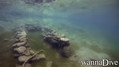
Nome alternativo Civilizatione lost
Profondità media 10 m / 32.8 ft
profondità massima 18 m / 59.1 ft
Corrente Nessuna
Visibilità Buona ( 10 - 30 m)
Qualità
Qualità del sito d'immersione Grande
Esperienza CMAS * / OW
Interesse biologico Nessuno
Più dettagli
Frequentazione durante la settimana
Frequentazione durante il Week-end
Tipo di immersione
- Acqua dolce
Attività per il sito
- Notturna
- Snorkeling / Apnea
- Fotografia
- Immersione agevole
Pericoli
Altre informazioni
English (Traduci questo testo in Italiano): A small village that was flooded after a rock slide that blocked the river that flows down the valley and formed an artificial lake and flooded a farm that still stands as one can see today
The lake is at an altitude of ca 200 meter's above sea level
English (Traduci questo testo in Italiano): A small village that was flooded after a rock slide that blocked the river that flows down the valley and formed an artificial lake and flooded a farm that still stands as one can see today
The lake is at an altitude of ca 200 meter's above sea level
A small village that was flooded after a rock slide that blocked the river that flows down the valley and formed an artificial lake and flooded a farm that still stands as one can see today
The lake is at an altitude of ca 200 meter's above sea level
English (Traduci questo testo in Italiano): A small village that was flooded after a rock slide that blocked the river that flows down the valley and formed an artificial lake and flooded a farm that still stands as one can see today
The lake is at an altitude of ca 200 meter's above sea level
English (Traduci questo testo in Italiano): A small village that was flooded after a rock slide that blocked the river that flows down the valley and formed an artificial lake and flooded a farm that still stands as one can see today
The lake is at an altitude of ca 200 meter's above sea level
English (Traduci questo testo in Italiano): A small village that was flooded after a rock slide that blocked the river that flows down the valley and formed an artificial lake and flooded a farm that still stands as one can see today
The lake is at an altitude of ca 200 meter's above sea level
English (Traduci questo testo in Italiano): A small village that was flooded after a rock slide that blocked the river that flows down the valley and formed an artificial lake and flooded a farm that still stands as one can see today
The lake is at an altitude of ca 200 meter's above sea level
English (Traduci questo testo in Italiano): A small village that was flooded after a rock slide that blocked the river that flows down the valley and formed an artificial lake and flooded a farm that still stands as one can see today
The lake is at an altitude of ca 200 meter's above sea level
English (Traduci questo testo in Italiano): A small village that was flooded after a rock slide that blocked the river that flows down the valley and formed an artificial lake and flooded a farm that still stands as one can see today
The lake is at an altitude of ca 200 meter's above sea level
 Commenti
Per favore login per usare questo strumento.
Non hai ancora un account? Registrati prima; è gratis!
Mostra tutto (0)...
Sii il primo a commentare questo paese
Errori, Segnalazione
Puoi modificare questa pagina per correggere errori o aggiungere altre informazioni. Se hai problemi riguardo questa pagina, Scrivi una recensione.
Wannadive.net 24/24
Wannadive.net sul tuo telefono

Newsletter Tutte le notizie per email
 Lyngstølsvatnet