Hai perso la password? Nuovo utente? Registra
Whale Shark, Philippines. Photo by Stephane Rochon.
Divertiti e contribuisci!
| Trova il miglior sito d'immersione |
|
|
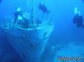
 Pinar 1
Turkey, Aegean, Bodrum
Questa è una mappa interattiva! usa i controlli zoom e pan.
|
Datum: WGS84 [ Aiuto ] |
Latitudine: 36° 58.08' N |
Giudizio dell'utente (0)
- Preferito
-
Lista dei tuoi punti d'immersione preferiti e futuri
Accesso
|
English (Traduci questo testo in Italiano): Black island Come? In barca Distanza Buona navigazione (< 30min) Facile da trovare? Facile da trovare |
Caratteristiche del sito d'immersione
Nome alternativo Black island
Profondità media 15 m / 49.2 ft
profondità massima 40 m / 131.2 ft
Corrente Poca ( < 1 nodo)
Visibilità Buona ( 10 - 30 m)
Qualità
Qualità del sito d'immersione Buono
Esperienza CMAS * / OW
Interesse biologico Interessante
Più dettagli
Frequentazione durante la settimana
Frequentazione durante il Week-end
Tipo di immersione
- Reef
Attività per il sito
- Fotografia
Pericoli
Altre informazioni
English (Traduci questo testo in Italiano): Many amphorae, groupers, nudibranchs
Autore: ysylon Hanno contribuito (1) Si sono immersi qua! (8)

 Commenti
Di markfldavison , 31-08-2009
Pinar - Turkish Naval Tanker Pinar This wreck was sunk 4 on the 20 May 2007. The small Tanker has a length of 37m and a beam of 7m and displaced 500 ton. The Pinar was built in 1938 and commissioned into the Turkish Navy in 1939. Clearly the Turkish Navy gets value for money from their investments! Again the engines were removed along with all hazardous materials, prior to sinking. The highest point of the wreck is 15m most of the deck is 20 - 25m with the bow sitting at 35m. The wheelhouse can be entered by suitably qualified and experienced divers
Errori, Segnalazione
Puoi modificare questa pagina per correggere errori o aggiungere altre informazioni. Se hai problemi riguardo questa pagina, Scrivi una recensione.
Pubblicità
Wannadive.net 24/24
Wannadive.net sul tuo telefono
![]()
RSS Tutti i RSS feeds di Wannadive.net
Newsletter Tutte le notizie per email