Questa è una mappa interattiva! usa i controlli zoom e pan.
Accesso
|
English (Traduci questo testo in Italiano): The dive site is in Halifax County, through the community of Hubbards, and on to Route 329 on the coastal road on the west side of St. Margaret's Bay. The spot is just past Mill Cove, once you enter the strip community of Birchy Head. It is marked by an old, broken down, and partially burnt FISH SHACK on the left side of the road going out...One has to turn around and park on the shoulder of the road facing back along by the shack. There is tight parking for 5 vehicles.
English (Traduci questo testo in Italiano): The dive site is in Halifax County, through the community of Hubbards, and on to Route 329 on the coastal road on the west side of St. Margaret's Bay. The spot is just past Mill Cove, once you enter the strip community of Birchy Head. It is marked by an old, broken down, and partially burnt FISH SHACK on the left side of the road going out...One has to turn around and park on the shoulder of the road facing back along by the shack. There is tight parking for 5 vehicles.
The dive site is in Halifax County, through the community of Hubbards, and on to Route 329 on the coastal road on the west side of St. Margaret's Bay. The spot is just past Mill Cove, once you enter the strip community of Birchy Head. It is marked by an old, broken down, and partially burnt FISH SHACK on the left side of the road going out...One has to turn around and park on the shoulder of the road facing back along by the shack. There is tight parking for 5 vehicles.
English (Traduci questo testo in Italiano): The dive site is in Halifax County, through the community of Hubbards, and on to Route 329 on the coastal road on the west side of St. Margaret's Bay. The spot is just past Mill Cove, once you enter the strip community of Birchy Head. It is marked by an old, broken down, and partially burnt FISH SHACK on the left side of the road going out...One has to turn around and park on the shoulder of the road facing back along by the shack. There is tight parking for 5 vehicles.
English (Traduci questo testo in Italiano): The dive site is in Halifax County, through the community of Hubbards, and on to Route 329 on the coastal road on the west side of St. Margaret's Bay. The spot is just past Mill Cove, once you enter the strip community of Birchy Head. It is marked by an old, broken down, and partially burnt FISH SHACK on the left side of the road going out...One has to turn around and park on the shoulder of the road facing back along by the shack. There is tight parking for 5 vehicles.
English (Traduci questo testo in Italiano): The dive site is in Halifax County, through the community of Hubbards, and on to Route 329 on the coastal road on the west side of St. Margaret's Bay. The spot is just past Mill Cove, once you enter the strip community of Birchy Head. It is marked by an old, broken down, and partially burnt FISH SHACK on the left side of the road going out...One has to turn around and park on the shoulder of the road facing back along by the shack. There is tight parking for 5 vehicles.
English (Traduci questo testo in Italiano): The dive site is in Halifax County, through the community of Hubbards, and on to Route 329 on the coastal road on the west side of St. Margaret's Bay. The spot is just past Mill Cove, once you enter the strip community of Birchy Head. It is marked by an old, broken down, and partially burnt FISH SHACK on the left side of the road going out...One has to turn around and park on the shoulder of the road facing back along by the shack. There is tight parking for 5 vehicles.
English (Traduci questo testo in Italiano): The dive site is in Halifax County, through the community of Hubbards, and on to Route 329 on the coastal road on the west side of St. Margaret's Bay. The spot is just past Mill Cove, once you enter the strip community of Birchy Head. It is marked by an old, broken down, and partially burnt FISH SHACK on the left side of the road going out...One has to turn around and park on the shoulder of the road facing back along by the shack. There is tight parking for 5 vehicles.
English (Traduci questo testo in Italiano): The dive site is in Halifax County, through the community of Hubbards, and on to Route 329 on the coastal road on the west side of St. Margaret's Bay. The spot is just past Mill Cove, once you enter the strip community of Birchy Head. It is marked by an old, broken down, and partially burnt FISH SHACK on the left side of the road going out...One has to turn around and park on the shoulder of the road facing back along by the shack. There is tight parking for 5 vehicles.
Come? Da riva
Distanza Breve camminata da riva (< 5min)
Facile da trovare? Facile da trovare
|
|
Caratteristiche del sito d'immersione
Profondità media 10 m / 32.8 ft
profondità massima 33 m / 108.3 ft
Corrente Nessuna
Visibilità Buona ( 10 - 30 m)
Qualità
Qualità del sito d'immersione Buono
Esperienza CMAS * / OW
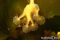
Interesse biologico Interessante
Più dettagli
Frequentazione durante la settimana
Frequentazione durante il Week-end
Tipo di immersione
- Profonda
- Ambientamento
Attività per il sito
- Biologia marina
- Notturna
- Allenamento
- Orientamento
- Fotografia
- Immersione agevole
Pericoli
Altre informazioni
English (Traduci questo testo in Italiano): The path down to the shoreline is around the right side of the FISH SHACK, and is a short scramble down small boulders to and easy walk to a small granite point jutting out into the water. This point offers easy water access and is 3-9' deep, depending on tide.
The diving is on a nice boulder slope running down to 40-50' to a gravel slope that gradually drops to ~100' deep. The rich seaweeds and marine life are in the top 40' of water.
It is calm in westerly winds, as it faces due east and is good for all level of divers in light northwest to southwest winds.
The path down to the shoreline is around the right side of the FISH SHACK, and is a short scramble down small boulders to and easy walk to a small granite point jutting out into the water. This point offers easy water access and is 3-9' deep, depending on tide.
The diving is on a nice boulder slope running down to 40-50' to a gravel slope that gradually drops to ~100' deep. The rich seaweeds and marine life are in the top 40' of water.
It is calm in westerly winds, as it faces due east and is good for all level of divers in light northwest to southwest winds.
English (Traduci questo testo in Italiano): The path down to the shoreline is around the right side of the FISH SHACK, and is a short scramble down small boulders to and easy walk to a small granite point jutting out into the water. This point offers easy water access and is 3-9' deep, depending on tide.
The diving is on a nice boulder slope running down to 40-50' to a gravel slope that gradually drops to ~100' deep. The rich seaweeds and marine life are in the top 40' of water.
It is calm in westerly winds, as it faces due east and is good for all level of divers in light northwest to southwest winds.
 Commenti
Per favore login per usare questo strumento.
Non hai ancora un account? Registrati prima; è gratis!
Mostra tutto (0)...
Sii il primo a commentare questo paese
Errori, Segnalazione
Puoi modificare questa pagina per correggere errori o aggiungere altre informazioni. Se hai problemi riguardo questa pagina, Scrivi una recensione.
Wannadive.net 24/24
Wannadive.net sul tuo telefono

Newsletter Tutte le notizie per email
 The fish shack