Hai perso la password? Nuovo utente? Registra
Big eye, Philippines. Photo by Stephane Rochon.
Divertiti e contribuisci!
| Trova il miglior sito d'immersione |
|
|
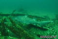
 Santore Wreck
USA, Virginia
Questa è una mappa interattiva! usa i controlli zoom e pan.
|
Datum: WGS84 [ Aiuto ] |
Latitudine: 36° 54' N |
Giudizio dell'utente (0)
- Preferito
-
Lista dei tuoi punti d'immersione preferiti e futuri
Accesso
|
English (Traduci questo testo in Italiano): Charter the Ms Lindsey. Come? In barca Distanza Buona navigazione (< 30min) Facile da trovare? Facile da trovare |
Caratteristiche del sito d'immersione
Profondità media 18.3 m / 60 ft
profondità massima m / ft
Corrente Poca ( < 1 nodo)
Visibilità Buona ( 10 - 30 m)
Qualità
Qualità del sito d'immersione Grande
Esperienza CMAS * / OW
Interesse biologico Interessante
Più dettagli
Frequentazione durante la settimana
Frequentazione durante il Week-end
Tipo di immersione
- Relitto
- Squali
Attività per il sito
- Notturna
- Prima immersione
- Allenamento
- Fotografia
Pericoli
Altre informazioni
Autore: Anonimo Hanno contribuito (1) Si sono immersi qua! (1)
 Foto
Foto
Santore Wreck |

Santore Wreck |

Santore Wreck |
Commenti
Errori, Segnalazione
Puoi modificare questa pagina per correggere errori o aggiungere altre informazioni. Se hai problemi riguardo questa pagina, Scrivi una recensione.
Pubblicità
Wannadive.net 24/24
Wannadive.net sul tuo telefono
![]()
RSS Tutti i RSS feeds di Wannadive.net
Newsletter Tutte le notizie per email
Di Anonymous , 09-08-2009
- A 7,117 ton bulk cargo carrier sunk after striking a mine laid by the U-701 on June 17, 1942. The starboard gunwale was awash after sinking and subsequently the wreck was reduced to an enormous pile of debris.