Questa è una mappa interattiva! usa i controlli zoom e pan.
Accesso
|
English (Traduci questo testo in Italiano): Jeffreys Ledge is a large glacially-created feature, stretching 33 miles from offshore of Rockport, MA to Cape Elizabeth, ME. Dive charters departing from Gloucester run special trips upon request.
English (Traduci questo testo in Italiano): Jeffreys Ledge is a large glacially-created feature, stretching 33 miles from offshore of Rockport, MA to Cape Elizabeth, ME. Dive charters departing from Gloucester run special trips upon request.
Jeffreys Ledge is a large glacially-created feature, stretching 33 miles from offshore of Rockport, MA to Cape Elizabeth, ME. Dive charters departing from Gloucester run special trips upon request.
English (Traduci questo testo in Italiano): Jeffreys Ledge is a large glacially-created feature, stretching 33 miles from offshore of Rockport, MA to Cape Elizabeth, ME. Dive charters departing from Gloucester run special trips upon request.
English (Traduci questo testo in Italiano): Jeffreys Ledge is a large glacially-created feature, stretching 33 miles from offshore of Rockport, MA to Cape Elizabeth, ME. Dive charters departing from Gloucester run special trips upon request.
English (Traduci questo testo in Italiano): Jeffreys Ledge is a large glacially-created feature, stretching 33 miles from offshore of Rockport, MA to Cape Elizabeth, ME. Dive charters departing from Gloucester run special trips upon request.
English (Traduci questo testo in Italiano): Jeffreys Ledge is a large glacially-created feature, stretching 33 miles from offshore of Rockport, MA to Cape Elizabeth, ME. Dive charters departing from Gloucester run special trips upon request.
English (Traduci questo testo in Italiano): Jeffreys Ledge is a large glacially-created feature, stretching 33 miles from offshore of Rockport, MA to Cape Elizabeth, ME. Dive charters departing from Gloucester run special trips upon request.
English (Traduci questo testo in Italiano): Jeffreys Ledge is a large glacially-created feature, stretching 33 miles from offshore of Rockport, MA to Cape Elizabeth, ME. Dive charters departing from Gloucester run special trips upon request.
Come? In barca
Distanza Navigazione lunga (> 30min)
Facile da trovare? Difficile da trovare
|
|
Caratteristiche del sito d'immersione
Profondità media 36.6 m / 120.1 ft
profondità massima 36.6 m / 120.1 ft
Corrente Media ( 1-2 nodi)
Visibilità Eccellente ( > 30 m)
Qualità
Qualità del sito d'immersione Grande
Esperienza CMAS ** / AOW
Interesse biologico Spettacolare
Più dettagli
Frequentazione durante la settimana
Frequentazione durante il Week-end
Tipo di immersione
- In corrente
- Pelagici
Attività per il sito
- Biologia marina
Pericoli
- Profondità
- Corrente
- Reti
Altre informazioni
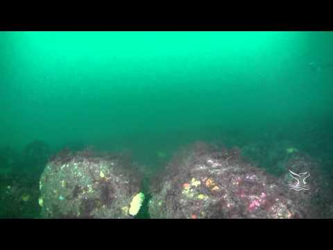
English (Traduci questo testo in Italiano): On the northern edge of NOAA's Stellwagen Bank National Marine Sanctuary, rocky ridges on the southern edge of Jeffreys Ledge rise to within 115 feet of the surface. The shallowest portion of the ledge is comprised of piled cobble and boulders. Anemones, stalked tunicates, and coralline algae reside on the rocks making for a colorful landscape when illuminated with a dive light. The ledge’s piled boulders create a complex structure with many crevices for marine fishes like cusk and wolffish.
For more information visit: http://stellwagen.noaa.gov/visit/diving/diving.html
On the northern edge of NOAA's Stellwagen Bank National Marine Sanctuary, rocky ridges on the southern edge of Jeffreys Ledge rise to within 115 feet of the surface. The shallowest portion of the ledge is comprised of piled cobble and boulders. Anemones, stalked tunicates, and coralline algae reside on the rocks making for a colorful landscape when illuminated with a dive light. The ledge’s piled boulders create a complex structure with many crevices for marine fishes like cusk and wolffish.
For more information visit: http://stellwagen.noaa.gov/visit/diving/diving.html
English (Traduci questo testo in Italiano): On the northern edge of NOAA's Stellwagen Bank National Marine Sanctuary, rocky ridges on the southern edge of Jeffreys Ledge rise to within 115 feet of the surface. The shallowest portion of the ledge is comprised of piled cobble and boulders. Anemones, stalked tunicates, and coralline algae reside on the rocks making for a colorful landscape when illuminated with a dive light. The ledge’s piled boulders create a complex structure with many crevices for marine fishes like cusk and wolffish.
For more information visit: http://stellwagen.noaa.gov/visit/diving/diving.html
 Commenti
Per favore login per usare questo strumento.
Non hai ancora un account? Registrati prima; è gratis!
Mostra tutto (0)...
Sii il primo a commentare questo paese
Errori, Segnalazione
Puoi modificare questa pagina per correggere errori o aggiungere altre informazioni. Se hai problemi riguardo questa pagina, Scrivi una recensione.
Wannadive.net 24/24
Wannadive.net sul tuo telefono

Newsletter Tutte le notizie per email
 Jeffreys Ledge